SGDrape
SGL´s Computer Aided Drape Flying System
High resolution geophysical data require surveys to be
flown at a consistent height above the ground. It is also
important that the survey aircraft maintains a consistent
and safe altitude on the two orthogonal survey line
directions. SGL has designed and implemented a
computer-assisted system, SGDrape, to enable the
company's flight crews to maintain an optimal flight
altitude (drape surface) during surveying while at the
same time ensuring that primary and control lines
intersect at the same altitude. The result has been a
vast improvement in the consistency of SGL´s high
resolution data acquired, particularly in hilly or
mountainous terrain.
To create a drape surface, a digital terrain model of the
survey area is modified to reduce all slopes to within the
capabilities of the survey aircraft to safely climb and
descend. The drape surface is then loaded into the survey
aircraft´s navigation system, SGNav, together with
the planned flight lines. As the aircraft flies along the
survey lines the navigation system provides guidance to
the flight crew using a modified Instrument Landing System
(ILS) indicator mounted in the cockpit, and the flight
crew matches the aircraft´s altitude to the planned
altitude for that location. Altitude information comes
from Real-time Differential GPS (RDGPS), or the aircraft´s
radar or laser altimeter.
A typical application for SGDrape is shown in the
diagram below, where the mountains rise out of the ocean
and reach an elevation of about 2000 m in only a few
kilometres. Without the drape flying program it is
difficult for the survey crew to fly adjacent and
orthogonal lines at a consistent altitude. Decisions must
be made as to when to start climbing while approaching a
hill or ridge, how deep into a valley to descend, how
steeply to descend off a ridge, and what altitude to fly
when flying parallel to a ridge to enable control lines to
intersect with all of the primary lines. The task of
defining the correct drape altitude is much better
performed by a computer using a digital terrain model,
leaving the flight crew more time to fly the aircraft,
watch for other aircraft and obstacles, and monitor the
survey instruments. The SGDrape system removes
the guesswork from the selection of survey altitudes in
rough topography, to enhance the quality of the final
data, and to improve the safety of the survey operation.
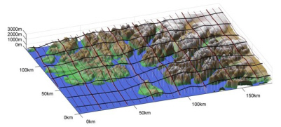
Rugged terrain with draped
flight lines - Nominal survey altitude of 300 m AGL
System Advantages
The main advantages of the SGDrape system are:
- Preparation of the drape surface allows for pre-survey
analysis and optimization of the survey line direction,
as well as a quantification of the achievable flying
height over the entire survey area. This results in
more efficient use of exploration dollars.
- Prior to survey flying clients can see what the drape
surface looks like and can examine what altitude the
sensors will be at over the entire survey area.
- Control line and traverse lines intersect at the same
altitude, which facilitates data levelling.
- The drape system is a tool which makes flying a smooth
drape much easier by extending the advantages of
electronic navigation to the third dimension, which
allows the flight crew to fly a better, safer survey.
The system effectively takes the guess work out of
maintaining a safe and consistent survey altitude.
- The drape surface removes significant differences in
the altitude between subsequent flights due to changing
weather conditions (wind, visibility, temperature, etc),
changing aircraft fuel load, and different flight crews.
Differences in the altitude of adjacent survey lines
flown in opposite directions are also minimized.
- The system is not an autopilot, so the pilot is always
in full control of the aircraft.
A digital terrain model is essential for the process. In
areas of steep topography, locations and altitudes of the
highest points are most important. Topography below the
highest points, which is beyond the climb/descent rate of
the aircraft need only be modelled in a very general
manner.
In many cases, surveys are flown in areas where only
small scale maps, sometimes of questionable accuracy, are
available. SGL endeavours to find, or create, the best
digital terrain model possible. We have found that SGDrape
is not particularly sensitive to minor inaccuracies in the
original terrain model, because the desired result is to
drape over the topography, not to follow the terrain
exactly, especially over very steep terrain.
The system also offers a significant safety advantage
because the rate of climb is limited before the start of
the survey operations to that which can be safely
maintained by the aircraft. SGDrape reduces pilot
workload and fatigue, leaving more time for the crew to
attend to other flight tasks. The company continues to
limit survey operations to good VFR conditions under
daylight hours allowing the flight crew to maintain a
careful lookout for uncharted obstacles and avoid
situations where the aircraft may be unable to maintain a
safe altitude and airspeed.
|