High Resolution
Frequency-Domain EM Surveys
Sander Geophysics has sixty years of worldwide experience
in high resolution airborne surveys and flew its first
electromagnetic (EM) survey in 1958. SGL offers
frequency-domain electromagnetic (FEM) surveys using a
fixed-wing aircraft. FEM systems generate electromagnetic
fields (primary field) which in turn induce secondary EM
fields that vary in amplitude and phase depending on the
electrical conductivity of the medium. At SGL, this
secondary field is measured by the receiver coils and then
separated into two components: the in-phase (or real)
component which is in phase with the primary field and the
quadrature (or imaginary) component which is 90°
out-of-phase with the primary field. The relationship
between the signal strengths of the two components is then
used to estimate the conductivity and depth of measured
anomalies. This system can be used for both mineral
exploration and environmental programs to:
- map lateral changes in geological conditions such as
changes in lithology and structure, as well as presence
of ore bodies;
- perform groundwater investigations;
- detect large buried metal objects.
Airborne Frequency-Domain EM Surveys at SGL
SGL's de Havilland DHC-6 Twin Otter can be configured
with a four-frequency wingtip mounted EM system (SGFEM).
This configuration results in a large transmitter-receiver
coil separation which improves the signal to noise ratio.
This allows surveys to be flown higher thus making the
system a viable option for surveying in areas where local
regulations restrict minimal flying altitudes.
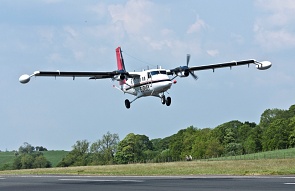
SGL´s de Havilland Twin Otter on
survey in Ireland
The transmitter-receiver coil pairs are mounted in a
vertical-coplanar orientation which reduces noise by
minimizing coupling with the wingtip surface.
Additionally, the coils in any one set (transmitter or
receiver) are axially offset and are kept adequately
separated from each other. The system also comes equipped
with a 50/60 Hz power line monitor which becomes
particularly useful in identifying cultural interference
when surveying in urban settings. Other ancillary
equipment includes radar and laser altimeters and a
real-time digital video recording system.
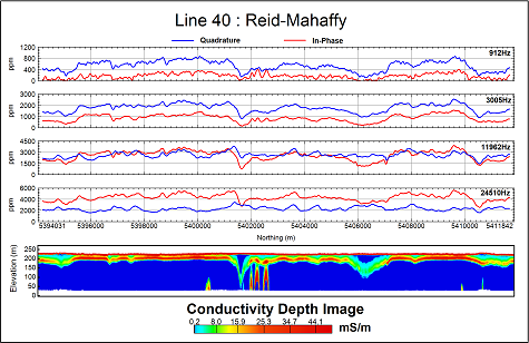
Test line over the Reid-Mahaffy
test site in Ontario showcasing all electromagnetic
components in profile plus CDI generated from all SGFEM
frequencies. The targets of interest can be seen in the
centre of the CDI along with the overburden across the
entire length of the line.
Other geophysical survey methods may also be employed
simultaneously with EM data acquisition. High resolution
aeromagnetic data can be gathered in conjunction with this
EM system. The cesium magnetometer sensor is mounted in
the receiver side (left) wingtip of the aircraft.
Acquiring horizontal magnetic gradient data is also
possible by housing an extra magnetometer in our custom
built nose stinger. The Twin Otter can also be fitted with
gamma ray detectors for radiometric surveying with a
detector volume tailored to fit the survey program
objectives. SGL uses SGSpec and Radiation Solutions Inc.
(RSI) spectrometers, which are recognized as the most
advanced airborne spectrometer systems available. Gravity
(AIRGrav) and methane detection are also compatible with
this system configuration.
Frequency-Domain EM Survey System
| Airborne Instruments |
| Electromagnetic System |
Frequencies (Hz) |
925 |
3,005 |
11,962 |
27,933 |
| Tx-Rx coil spacing
(m) |
21.35 |
21.35 |
21.38 |
21.38 |
| Supplementary Systems |
Power line monitor (50/60 Hz)
Sferics monitor |
| Data Acquisition System |
Sander Geophysics — SGDAS
airborne computer
Capable of recording unlimited number of channels at
variable intervals, and digital scrolling chart
display of the data. Data are recorded on a
vibration tolerant removable drive. The system
clock is a quartz time standard automatically
synchronized to UTC by the GPS signal to an accuracy
of 1 millisecond. |
| Video
Imaging System |
Sander Geophysics — SGDIS
digital video |
| |
|
Resolution (m) |
Calibrated to |
Range
(m) |
| Laser Altimeter |
Riegl LD90-3300VHS-FLP |
0.25 |
<1% |
0 to
10,000
(33,000 ft) |
| Radar Altimeter |
Collins |
0.5 |
1% |
0 to 760
(2,500 ft) |
| Barometric Altimeter |
Honeywell TJE |
2.0 |
±4 m |
0 to
10,000
(30,000 ft) |
Instruments for Simultaneous Multidisciplinary Surveys
| MAGNETICS |
| Sensor |
Geometrics
Strap-down, optically pumped, cesium split beam
Sensitivity: 0.005 nT
Sensor noise level: < 0.02 nT
Sampling rate: 10 Hz |
| Compensator |
Sander Geophysics — AIRComp
real-time digital compensation
Range: 20,000 to 200,000 nT
Resolution: 0.001 nT
Sampling rate: 160 Hz |
| RADIOMETRICS |
| Spectrometer |
SGSpec or Radiation Solutions
RS-500 |
| Detector Volume |
16.8 to 50.4 litres of
downward-looking crystals
4.2 to 12.6 litres of upward-looking crystals |
| GRAVITY |
| Gravimeter |
Sander Geophysics — AIRGrav,
Airborne Inertially Referenced Gravimeter |
| METHANE |
| Analyzer |
Sander Geophysics — SGMethane,
methane gas sensing system |
|