Environmental Monitoring Using
Gamma-ray Spectrometers
The energies of gamma-rays produced by radioactive decay
are characteristic of the decaying nuclide. For example
potassium-40 (40K) decays to argon-40 (40Ar)
with the emission of gamma-rays at 1460 keV. Gamma-ray
spectrometers are designed to measure the intensity and
energies of gamma-rays and hence measure the distribution
of particular radioactive nuclides.
Airborne gamma-ray spectrometry commenced in the late
1960´s, primarily for uranium exploration. Since the
mid-1970´s, the method has been applied extensively in
support of geological mapping and mineral exploration.
Airborne gamma-ray spectrometry can also be used for
environmental monitoring. Radioactive debris from the
Russian nuclear satellite Cosmos 954 was successfully
located by airborne gamma-ray spectrometry. It has also
been used for mapping radioactive contamination from the
Chernobyl nuclear accident and for mapping radioactive
plumes from nuclear reactors.
Sander Geophysics has over forty years experience
conducting high resolution gamma-ray spectrometer surveys
in Canada and internationally. The company offers
airborne environmental mapping of natural and
anthropogenic radiation using gamma-ray spectrometers
flown in fixed-wing aircraft and helicopters, as well as
ground surveys using suitable vehicles.
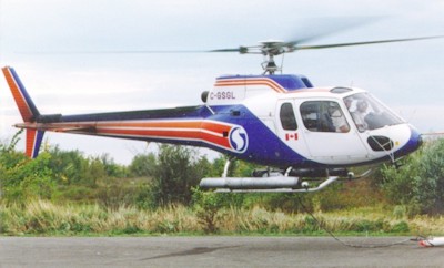
Aerospatiale Astar 350D equipped
for environmental monitoring
Survey Platform
Due to their slow speed, helicopter-borne surveys are
capable of defining small anomalies and result in data of
high resolution and sensitivity. However, fixed-wing
aircraft have lower operating costs and some specialized
fixed-wing aircraft, like Sander´s BN2B Islander, can
safely survey at speeds as low as 90 knots (175 km/h),
resulting in economical high resolution data.
Ground-based vehicle surveys offer increased resolution
at a low cost, and are ideal for relatively small areas
with good ground access.
Spectrometer System
All of Sander Geophysics´ gamma-ray spectrometer systems
use modern NaI crystals and offer full 256 channel
recording. This ensures that the exact nature and energy
level of the recorded radiation can be determined
accurately, and quantitative maps of individual nucleides
such as K, U, Th, Cs and others can be made.
Sander Geophysics´ fixed-wing aircraft can accommodate 50
litres (3000 cu in) of downward facing crystals and 8.4
litres (500 cu in) of upward facing crystals. Helicopter
systems accommodate up to 33 litres facing down and 8.4
litres facing up. Our ground-based systems use up to 16.8
litres depending on the desired resolution and vehicle
speed. In addition, all our aircraft and ground vehicles
are equipped with an integrated navigation system, SGNav,
utilising a NovAtel 24-channel GPS (Global Positioning
System) receiver, for precise navigation and accurate
flight path recovery.
Specialized Processing
Sander Geophysics has implemented a spectral component
analysis technique, based on the method of Hovgaard and
Grasty (of Exploranium and Gamma-Bob respectively). This
noise reduction technique, called Noise Adjusted Singular
Value Decomposition (NASVD), uses the full spectrum data
to enhance the resolution of radiometric data. Sander
also uses a combination of spectrum fitting and NASVD to
produce maps of cesium and other man-made nuclides from
the 256 channel radiometric data.
A Case Study
Recently, airborne gamma-ray spectrometry has been used
to identify and quantify the distribution of natural and
man-made gamma emitting isotopes in the vicinity of
nuclear power plants in order to assess the plant´s dose
impact on members of the public. In addition, the data
provide an environmental baseline of the nuclear operating
site and the surrounding community. In the event of an
accidental release of radiation from the facility, a
subsequent survey could then be used to determine any
increase in dose to the public.
Ideally, a gamma-ray spectrometer survey of a nuclear
facility will demonstrate that the gamma radiation
produced at the facility is localized to the containment
structures and the waste storage sites, and that no
radiation from the reactor or waste storage operations is
detected outside the plant boundary. Confidence in the
facility is further enhanced if the natural radiation
levels in the areas outside the plant boundaries are shown
to be typical of the levels found within the rest of the
country.
In the fall of 1999, Sander Geophysics flew an airborne
gamma-ray survey over the primary zone of the Pickering
Nuclear Generating Station in Ontario, Canada. The survey
was designed to address public concern of possible soil
contamination resulting from the operation of the
facility, and was flown under contract to Ontario Power
Generation (OPG), formerly Ontario Hydro.
 The survey showed that the radiation levels in the
surrounding community are comparable to the values
reported by the Geological Survey of Canada (GSC) as
typical for Ontario. Within the plant boundary, several
radioactive isotopes resulting from normal plant
operations were detected within acceptable limits. These
isotopes included cobalt-60 (60Co), cesium-137
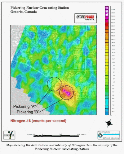
(137Cs) and nitrogen-16 (16N). Shown
above is a map of the 16N distribution within
the survey area, with an aerial photograph as a
background. Clearly visible are the four operating
Pickering "B" reactor units, which show up as a localized
area of high intensity (yellow-red) on the map. To the
left of this high are the Pickering "A" reactor units
which are shut down. Also apparent, is the generally low
intensity (green-blue) of the area immediately adjacent to
the plant and out into the surrounding community.
The results of the survey have familiarized the public
with existing levels of both natural and man-made gamma
radiation, and verified that there are no gamma emitting
radioactive materials in the surrounding residential
community due to the operation of the nuclear generating
station.
|