 |
|
|---|---|
 |
|
|
|

Company ProfileSander Geophysics Limited (SGL) provides worldwide airborne geophysical surveys for petroleum and mineral exploration, and geological and environmental mapping. Services offered include high resolution airborne gravity, magnetic, electromagnetic, and radiometric surveys, using fixed wing aircraft and helicopters. |
|
Dr. George W. Sander (1924-2008) founded SGL in 1956, to provide ground geophysical surveys. The first airborne surveys were performed as early as 1958, and by 1967 airborne geophysical surveys were the company's main focus. Operations have expanded steadily since SGL was founded 60 years ago. The company is led by co-presidents Luise Sander and Stephan Sander. |
Worldwide OperationsSGL's head office and aircraft maintenance hangar are located at the international airport in Ottawa, Canada. Sander Geophysics has operated on every continent including Antarctica, and under diverse conditions ranging from the tropics, deserts, mountains, and offshore. 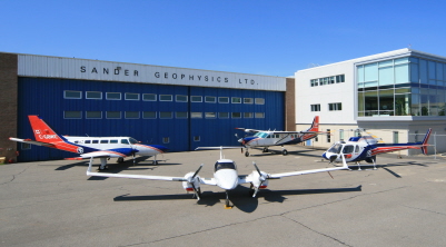
SGL head office and hangar in Ottawa, Canada Facilities at the head office include a state of the art data processing department with an integrated digital cartographic department and a fully equipped electronics workshop for research, development and production of geophysical instruments. A Transport Canada Approved Maintenance Organization (AMO) for fixed wing aircraft and helicopters allows most aircraft maintenance and modifications to be performed in-house. |
ServicesAirborne Surveys
SGL offers gravity surveys with AIRGrav (Airborne Inertially Referenced Gravimeter), which was designed specifically for the unique characteristics of the airborne environment, and is the highest resolution airborne gravimeter available. AIRGrav can be flown in an efficient survey aircraft during normal daytime conditions and is routinely flown in combination with magnetometer systems in SGL's airplanes and helicopters. 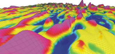
AIRGrav data: Data ProcessingImmediate data processing is part of SGL's standard quality control procedure, and provides clients with rapid results for evaluation while a survey is in progress. Sander Geophysics offers a full range of data enhancement programs and integrated interpretation services by experienced geoscientists. Available products in digital and/or hard-copy include:
Environmental MonitoringThe company also provides environmental monitoring services using gamma-ray spectrometers and specialized processing to detect and quantify natural and anthropogenic radiation, as well as accurate methane mapping and monitoring using SGMethane. |
Health & SafetySander Geophysics is a founding and active executive member of the International Airborne Geophysics Safety Association (IAGSA), which promotes the safe operation of helicopters and fixed wing aircraft on airborne geophysical surveys. SGL has developed and implemented a Safety Management System (SMS) and comprehensive Health, Safety and Environment (HSE) policies that govern all aspects of company operations. Safety initiatives include:
SGL's excellent safety record is attributed to the quality and experience of its survey crews. This, combined with management's ongoing commitment to safety helps to ensure that Sander Geophysics is a safe and reliable choice for airborne geophysical surveys. |
PersonnelSander Geophysics has over 160 experienced full-time employees, including geophysicists, software and hardware engineers, aircraft maintenance engineers and pilots. |
AircraftSGL owns and operates twelve aircraft, including eight Cessna Grand Caravans, two de Havilland Twin Otters and two Airbus AS350 B3 helicopters all equipped for magnetic, radiometric and gravity geophysical surveys. All SGL survey aircraft are capable of acquiring multiple geophysical data simultaneously thus providing a more complete geological picture. 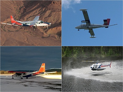
SGL aircraft Extensive modifications have been made to all of the survey aircraft to accommodate geophysical instruments and to reduce he aircraft’s magnetic field. Typical Figures of Merit (FOM) for Sander Geophysics' fixed wing aircraft are less than 1 nT. The Cessna Grand Caravans have been modified to allow the installation of a triaxial magnetic gradiometer system, and the Twin Otters, can be equipped with a frequency domain electromagnetic system. The company’s aircraft are flown and maintained by licensed and experienced permanent employees of Sander Geophysics. |
Research & DevelopmentNearly one-third of SGL's resources are devoted to developing new and more efficient instrumentation and techniques for airborne geophysical surveying, and to further refine its full suite of software for geophysical data processing. |